


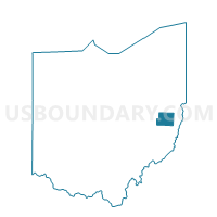
PRECINCT MOOREFIELD TWP, Harrison County, Ohio
About
Outline

Summary
| Unique Area Identifier | 647882 |
| Name | PRECINCT MOOREFIELD TWP |
| County | Harrison County |
| State | Ohio |
| Area (square miles) | 27.54 |
| Land Area (square miles) | 26.88 |
| Water Area (square miles) | 0.66 |
| % of Land Area | 97.62 |
| % of Water Area | 2.38 |
| Latitude of the Internal Point | 40.19489060 |
| Longtitude of the Internal Point | -81.15421950 |
Maps


Graphs
Select a template below for downloading or customizing gragh for PRECINCT MOOREFIELD TWP, Harrison County, Ohio


Neighbors
Neighoring Voting District (by Name) Neighboring Voting District on the Map
- Voting District FLUSHING TWP 1, Belmont County, OH
- Voting District HOLLOWAY, Belmont County, OH
- PRECINCT ATHENS TWP/VIL, Harrison County, OH
- PRECINCT CADIZ TWP/VIL NE, Harrison County, OH
- PRECINCT FREEPORT TWP/VIL, Harrison County, OH
- PRECINCT NOTTINGHAM TWP, Harrison County, OH
- PRECINCT WASHINGTON TWP, Harrison County, OH
Top 10 Neighboring County Subdivision (by Population) Neighboring County Subdivision on the Map
- Cadiz township, Harrison County, OH (3,689)
- Flushing township, Belmont County, OH (2,021)
- Freeport township, Harrison County, OH (745)
- Washington township, Harrison County, OH (638)
- Athens township, Harrison County, OH (505)
- Moorefield township, Harrison County, OH (403)
- Nottingham township, Harrison County, OH (324)
Top 10 Neighboring Place (by Population) Neighboring Place on the Map
Top 10 Neighboring Unified School District (by Population) Neighboring Unified School District on the Map
- Harrison Hills City School District, OH (13,866)
- Union Local School District, OH (9,175)
- Barnesville Exempted Village School District, OH (8,065)
Top 10 Neighboring State Legislative District Lower Chamber (by Population) Neighboring State Legislative District Lower Chamber on the Map
Top 10 Neighboring State Legislative District Upper Chamber (by Population) Neighboring State Legislative District Upper Chamber on the Map
Top 10 Neighboring 111th Congressional District (by Population) Neighboring 111th Congressional District on the Map
Top 10 Neighboring Census Tract (by Population) Neighboring Census Tract on the Map
- Census Tract 106, Belmont County, OH (3,712)
- Census Tract 9758, Harrison County, OH (2,346)
- Census Tract 9759, Harrison County, OH (2,280)